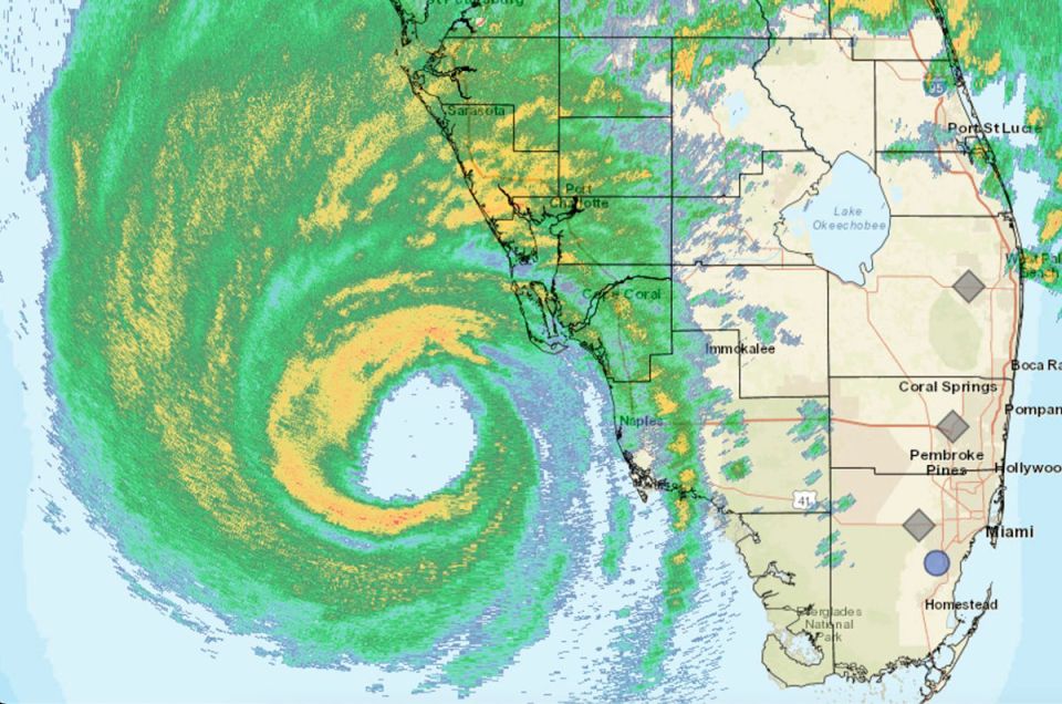
Before the arrival of Hurricane Ian, the Florida authorities launch alert calls to ask the population to take refuge “Right now!”
Powerful gusts of wind and rain show the intensity of Hurricane Ian, category 4, whose eye made landfall in southwest Florida on Wednesday afternoon, according to the National Hurricane Center (NHC) of the United States. Joined.
305 PM EDT 28 Sep — Hurricane #Ian has made landfall as an extremely dangerous Category 4 hurricane near Cayo Costa, Florida with maximum sustained winds at 150 mph. The minimum pressure from Air Force Reconnaissance Hurricane Hunters was 940 mb.
Latest: https://t.co/tnOTyfORCw pic.twitter.com/O3agPDOZHk
— National Hurricane Center (@NHC_Atlantic) September 28, 2022
WATCH: Destroyed buildings, homes floating away in Fort Myers Beach, Florida pic.twitter.com/EIy5oxo8c1
— BNO News (@BNONews) September 28, 2022
Through a tweet and a press conference, Florida Governor Ron DeSantis reported that Ian had already made landfall and that his government was ready to respond to the emergency, anticipating the official report from the National Hurricane Center.
“#HurricaneIan is making landfall now. Florida is ready to respond. We have fleets of high-altitude vehicles, 42,000 linemen, 7,000 National Guardsmen and 179 aircraft ready to help,” he noted.
#HurricaneIan is making landfall now. Florida is ready to respond. We have fleets of highwater vehicles, 42,000 linemen, 7,000 National Guardsmen and 179 aircraft prepared to help.
— Ron DeSantis (@GovRonDeSantis) September 28, 2022
Before the arrival of the eye of Hurricane Ian, the Florida authorities launched constant alert calls to ask the population to take refuge “Right now!”.
“An extreme wind warning is in effect for Cape Coral FL, Bonita Springs FL, Estero FL until 12:45 p.m. m. EDT for extremely dangerous hurricane force winds. Treat these impending extreme winds like an approaching tornado and immediately move to an interior room or shelter RIGHT NOW!” reads a twitter message from the National Weather Service Tampa Bay Area, Florida.
An extreme wind warning is in effect for Cape Coral FL, Bonita Springs FL, Estero FL until 12:45 PM EDT for extremely dangerous hurricane winds. Treat these imminent extreme winds as if a tornado was approaching and move immediately to an interior room or shelter NOW!. pic.twitter.com/Noc5LcsZIt
— NWS Tampa Bay (@NWSTampaBay) September 28, 2022
The National Hurricane Center (NHC) also warned of “catastrophic winds” and “life-threatening storm surge” affecting the west coast of Florida.
WATCH: Storm surge in Fort Myers, Florida as Hurricane Ian approaches pic.twitter.com/zVFbqAMbzp
— BNO News (@BNONews) September 28, 2022
More than 3 million people were evacuated and sent to various shelters, while gusts of wind lashed homes and hotel zones.
Florida Governor Ron DeSantis declared a state of emergency for the entire state and has activated 5,000 National Guard soldiers to help the population.
Ron DeSantis also warned that millions of people, close to 230,000 homes, could be without power for at least 48 hours due to the passage of this hurricane.
A video broadcast through social networks shows the moment of strong turbulence suffered by the famous hurricane hunting plane of the United States Air Force when flying over Hurricane Ian.
The Consulate General of Mexico in Miami made available to Mexican citizens emergency numbers and addresses of shelters where they can go.
According to forecasts, Hurricane Ian could cross the Florida peninsula, hitting Orlando, and reach the east coast to continue towards the north of the United States towards Jacksonville.

