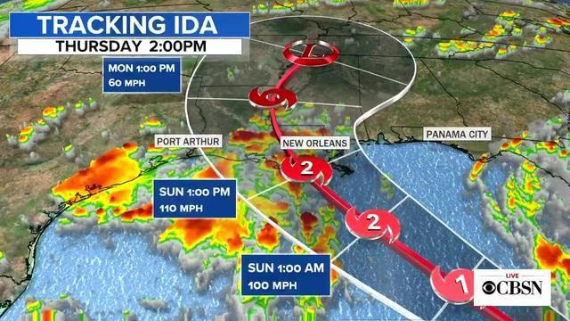
MIAMI – Tropical Storm Ida formed in the Caribbean on Thursday and meteorologists reported that its trajectory points to the US coast of the Gulf of Mexico, prompting the governor of Louisiana to declare a state of emergency and the emission of a hurricane watch for the New Orleans area
“Unfortunately, the entire Louisiana coast is currently in the forecast cone for Tropical Storm Ida, which is getting stronger and could hit the Louisiana coast as a major hurricane, as conditions in the Gulf they are conducive to escalating rapidly, ”Edwards said.
“By Saturday night, everyone should be in the place where they intend to pass the storm,” added the governor.
According to the National Hurricane Center of the United States, Ida is expected to cross the western fringe of Cuba – rich in tobacco cultivation – starting Friday still as a tropical storm and subsequently strengthening before reaching the Gulf Coast on Sunday.
“There is an increasing risk of life-threatening storm surges, damaging hurricane-force winds and heavy rain between Sunday and Monday, particularly off the coast of Louisiana,” said the Hurricane Center.
“Ida does indeed have the potential to be very damaging,” said Brian McNoldy, a hurricane researcher at the University of Miami.
A hurricane watch has been issued ranging from Cameron, Louisiana, to the Mississippi-Alabama border – including Lake Pontchartrain, Lake Maurepas and the New Orleans metropolitan area.
As of late Thursday, Ida had maximum sustained winds of 65 kilometers per hour (40 miles per hour) and was moving northwest at about 19 km / h (12 mph).
Its vortex was about 105 kilometers (65 miles) southeast of Grand Cayman and 585 kilometers (365 miles) southeast of the western tip of Cuba.
Tropical storm-force winds extended up to 110 kilometers (70 miles) north of the center.
The storm is expected to drop between 15 and 30 centimeters (6 and 12 inches) of rain in parts of Jamaica, Cuba and the Cayman Islands, with the possibility of heavier precipitation in isolated areas.
Forecasters warned of possible flash floods and mudslides and storm surges between 60 and 120 centimeters (2 to 4 feet) above normal, along with “large and destructive waves.”
The Cayman Islands government said non-essential government offices closed at 2:30 p.m. Thursday and four shelters were activated.

