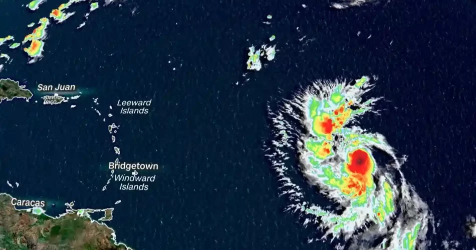
Lee rapidly intensified to a hurricane as it advances over a warmer-than-ever Atlantic Ocean, reaching sustained winds of 120 km/h, the National Hurricane Center (NHC) reported in the 5:00 p.m. Miami time bulletin.
Warm ocean waters are expected to continue to strengthen the cyclone to near Category 5 hurricane strength as it approaches the eastern Caribbean.
Lee was located more than 1,800 km east of the northern Leeward Islands, the NHC said.
The cyclone strengthened rapidly during this Wednesday: its sustained winds increased to 56 km/h in the 24 hours following its formation as a tropical depression on Tuesday morning.
Along those lines, even more rapid intensification is expected: defined as an increase in wind speed of at least 56 km/h in 24 hours or less over the next few days. The forecast track takes the hurricane through some of the warmer waters of the Atlantic Ocean and through relatively calm upper-level winds, which will allow Lee to increase in strength. By Friday night, Lee is expected to be a monster Category 4 hurricane with sustained winds of 150 mph (240 km/h).
The Atlantic waters are not as warm as the hot conditions in the Gulf of Mexico, which spawned Hurricane Idalia last week. However, according to David Zierden, a Florida state climatologist, sea surface temperatures in the part of the Atlantic Ocean that Lee will cross are still 2 °C (3.6 °F) above normal, after reaching “well above record levels” this northern summer.
“To reach a Category 4 or 5 intensity, the environment has to be near perfect, as appears to be the forecast for Lee,” Zierden told.
Lee’s forecast maximum intensity of 150 mph (240 km/h) is equivalent to that of the strongest storm in the Atlantic basin this season, Hurricane Franklin, and higher than any storm in the eastern Pacific. If Lee exceeds 150 mph, it will be the most powerful hurricane to travel through both basins this year.
This forecast is also only 10 km/h below Category 5.
And for Jason Dunion, director of NOAA’s Hurricane Program, “this storm has the potential to reach Category 5,” he told.
The last Category 5 hurricane to travel through the Atlantic basin was Hurricane Ian in 2022. Before that, 2019’s Dorian and Lorenzo were the most recent hurricanes to accomplish the feat. Since 1924, there have only been 39 Category 5 hurricanes, according to NOAA data.
Lee’s possible path threatens the islands this weekend.
Lee’s strength will ultimately determine the intensity and extent of its effects. Lee will begin to affect the Lesser Antilles, including the Leeward and Windward Islands, this Friday. Storm surges are likely to cause potentially deadly waves and rip currents on islands such as Barbados, Martinique, St. Lucia, and the British and U.S. Virgin Islands.
Any changes in Lee’s track as it approaches the Leeward Islands would increase the threat of more direct impacts, such as torrential rain and high winds. Anyone in the eastern Caribbean, including the Leeward Islands, Puerto Rico and Hispaniola, as well as the Bahamas, should keep a close eye on the forecast heading into the weekend.
It is too early to know if this system will directly affect the U.S. mainland, but even if the hurricane stays offshore, dangerous surf and rip currents could again threaten the East Coast. In fact, one person died in an undertow current in New Jersey over the Labor Day weekend.
Lee will increase in intensity as the peak of the Atlantic hurricane season approaches. Sunday, September 10 will be the climatological peak of the Atlantic hurricane season, when the basin is at its most active, on average. A surge of tropical activity around this date is not out of the ordinary, but it can quickly become dangerous.
The 2023 Atlantic season has already been intense: according to Philip Klotzbach, a research scientist at Colorado State University, it is above average in terms of number of named storms, number of hurricanes, and number of major hurricanes.

