Widespread Hurricane Lee continues to create hazards along U.S. East Coast
Category and significantly larger Hurricane Lee will continue to grow as it moves through the Atlantic Ocean along the east coast of the United States
Hurricane Lee grew even larger on Tuesday and triggered a tropical storm warning for Bermuda as potential impacts from the cyclone begin to focus on Bermuda and the U.S. East Coast this week, according to the National Hurricane Center (NHC) report
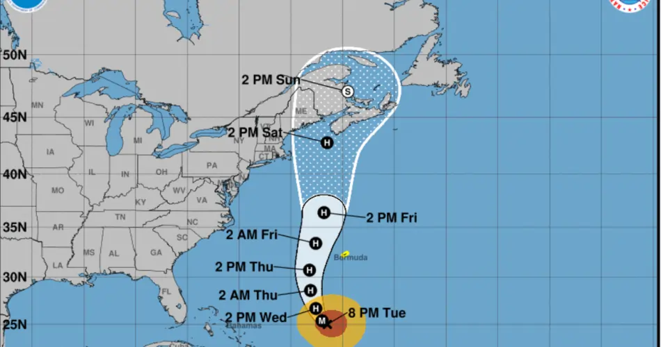
Lee, a Category 3 hurricane, was about 515 miles south-southwest of Bermuda on Tuesday night, with maximum sustained winds of 115 mph, according to the NHC.
The storm has been growing in size since the weekend and hurricane-force winds now extend 125 miles from Lee’s center. Tropical storm-force winds extended 240 miles from its core Tuesday night.
Hurricane Lee began moving northward along the U.S. East Coast Tuesday, with the risk of dangerous storm surge and storm surge.
Lee strengthens to hurricane and could intensify to Category 5 in a warmer-than-ever Atlantic Ocean
What are the risks to the United States?
As of Tuesday afternoon, Lee had winds of 115 mph and was moving west-northwestward at a virtual pace of only 6 mph. It is expected to turn further northward by the middle of this week and the timing of that turn is going to influence how it will affect the northeastern United States and the Atlantic coast of Canada.
The storm will send large waves to a large area of the East Coast throughout the week as it moves northward. This will cause coastal erosion, dangerous waves and potentially deadly rip currents on beaches.
Dangerous waves were already occurring along the southeast U.S. coast from Florida to the Carolinas, and a high risk of rip currents was in effect at least through Wednesday night in coastal areas from Florida to Massachusetts.
Dangerous waves and life-threatening rip currents will affect parts of the northern Leeward Islands, the Virgin Islands and Puerto Rico, Hispaniola, the Turks and Caicos Islands, the Bahamas,
Bermuda and most of the U.S. East Coast for much of the week.
The current forecast track shows Lee’s center moving toward New Brunswick, Canada, but along the way, its winds could reach coastlines from New York to Maine.
“It is still too early to know what level of additional impacts Lee could have along the northeast coast of the United States and Atlantic Canada later this week,” the NHC said Tuesday.
Category 3 Hurricane Lee Approaching New York: Possible Impact on Tri-State Area
Risks from Hurricane Lee during the week.
Tropical storm conditions, heavy rain and storm surge are expected to impact Bermuda beginning Wednesday night or early Thursday, and a tropical storm warning has been issued for the islands.
It is still too early to know what level of additional impacts Lee could have along the northeast coast of the United States and Atlantic Canada during this week, given that wind and rain hazards will spread well away from the center as Lee grows in size, Lee forecast updates should continue to be monitored over the next several days.

