- The hurricane Ian had been downgraded to a tropical storm and resumed hurricane force in the Atlantic on Thursday, just 12 hours after losing that status.
The hurricane Ian approaches the states of Georgia, South Carolina and North Carolina on the East Coast of the United States, where heavy rain, flooding, storm surge, and high winds are forecast.
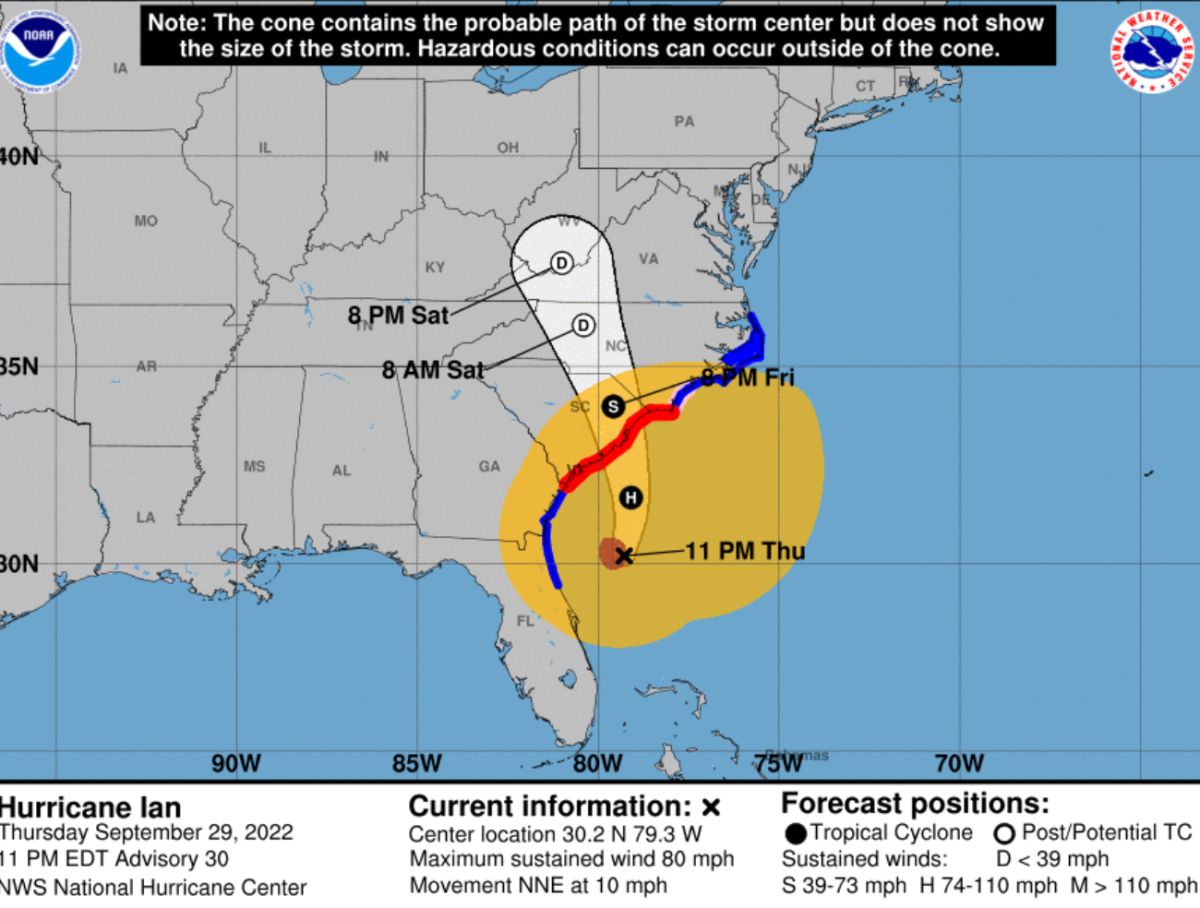
The US National Hurricane Center (NHC) bulletin at 11:00 pm ET notes that Ian heads to the Carolinas and Georgia with maximum sustained winds of 80 miles per hour (130 k / h), which maintains it as a category 1 hurricane on the Saffir-Simpson scale.
At the time of issuing the bulletin, Ian was located 185 miles (295 km) from Charleston, South Carolina.
Ian is moving to the north-northeast about 10 miles per hour (17 km/h) and a turn to the north is expected early on Friday, followed by a further turn to the north-northwest with an increase in airspeed. transfer Friday night.
On the predicted path, Ian will approach the coast of South Carolina on Friday. The center will move farther inland across the Carolinas on Friday night and Saturday.
Ian could strengthen slightly before landfall tomorrow and is forecast to rapidly weaken over the southeastern United States through Friday and into Saturday.
Hurricane-force winds extend outward up to 45 miles (75 km) from the center, and tropical-storm-force winds extend outward up to 415 miles (665 km).
The bulletin details that tropical storm conditions are still recorded in parts of the east coast of Florida and should extend north along the coasts of Georgia and North Carolina tonight and through Friday.
Hurricane conditions are possible within the hurricane watch area in northeast Florida and Georgia through Fridayand in the North Carolina watch area Friday morning.
Ian is expected to produce 1 to 3 inches of rain in coastal Georgia areas with locally heavier amounts.
In northeastern South Carolina 4 to 8 inches, with a local maximum of 12 inches, while in central South Carolina, North Carolina and southern Virginia it will drop from 3 to 6 inches with a local maximum of 8 inches.
The swells generated by Ian are affecting the northern coast of Cuba, the northeast coast of the Yucatan Peninsula, Florida and Georgia.

